I Found Snow and it Tried to Get Me Lost: Day Hiking From Tahoe to Truckee
This post comes from Rachel McCullough, an avid hiker, mountain biker, rock climber, yogi, skier and photographer living in Truckee, CA. Follow @rachelmcphotos on Instagram for stunning images of beautiful Sierra scenery. When Rachel isn’t enjoying her free time in the outdoors, she’s teaching skiing at Northstar California or building and marketing websites for her clients at McCullough Web Services.
Who: Rachel, Adam
What: Hiking
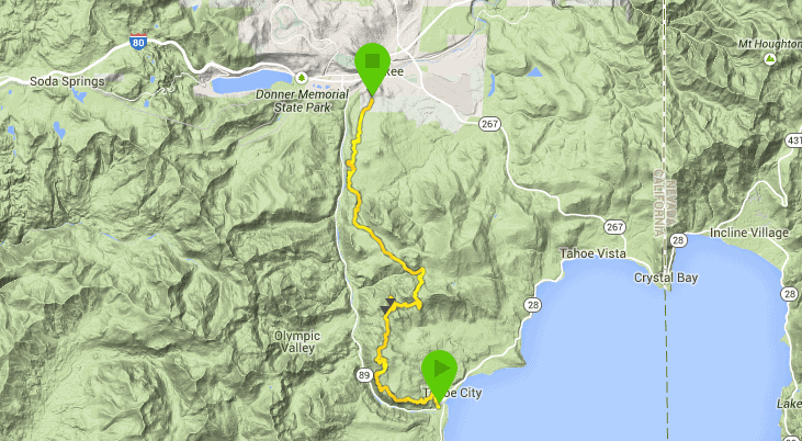
Where: From Tahoe City to Truckee, along the Tahoe Rim Trail and the 06 Forest Road
When: April 2015

“Did you do an idiot check?” I asked Adam as we left our rest spot.
I plan some of my hikes months ahead of time, like Kilimanjaro. Most are a few weeks out, but I dreamed up last Saturday’s hike the day before. Somehow all the pieces fell in place despite the fact that this particular hike required a shuttle and I had no car for the weekend.
A college friend of mine, Adam, was planning on coming up for a day of climbing, but we decided it was a little bit on the chilly side. Sometimes when you are feeling a bit wimpy about one thing, it doesn’t make sense to change your plan to something else that is different, yet harder. But, that’s exactly what happened.
When I suggested hiking instead of climbing, he agreed with the caveat that we had to do a long hike. I didn’t think he’d been keeping up on my TMS blog adventures of my long day-hikes like Lukens Lake to Tenaya Lake, which came in at 26 miles, so I proposed something a bit shorter, but still probably not quite what Adam was imagining when he said long.
I always thought it would be fun to walk from my neighborhood in Truckee, Sierra Meadows, to Lake Tahoe. It looked like about 20 miles or so on the map (it turned out to be 22), although there were longer variations. He said that sounded good, so I started to round up some gear, including my test products for the day, the Ultimate Direction Fastpack 20 and the Suunto Ambit3 Peak GPS Watch, and asked around about how much snow we might encounter. Surprisingly, I had very little hiking and biking experience in what is literally my own back yard, but fellow ambassador, Mike Tebutt, and TMS owner, Dave Polivy, were full of advice about both recent conditions and helped me draw out trails on my map that didn’t seem to be documented anywhere.
Then I started my excuse prep, seeing as I wasn’t entirely confident about a 20+ mile hike as my first real distance of the season. Excuse prep involves thinking of every possible reason why you might not succeed or might be slow, and then letting your partner and everyone else possible know in advance. That way, all your excuses are made ahead of time and it’s easier to tell people that you failed. So I run through my list with Adam and anyone who will listen, which included: I jogged twice already this week, I had just done a workout that involved the words boot camp, I hadn’t hiked more than 4 miles in a stretch this spring, and my hiking boots hurt my feet, so I only like to do long distances in running shoes (not possible because of the snow). Adam’s list was actually much shorter and included something like he was off the couch and lived at sea level.
So as we made our excuses, I started thinking it made more sense to hike from the Lake Tahoe back to Truckee rather than the other way around. That way we could more leisurely make our way back instead of racing for the last TART bus to get back to Truckee at the end.
We got the first bus in Truckee at 7:30 AM and our adventure began at the Tahoe Rim Trail (TRT) trail head in Tahoe City.

It was on the cool side and cloudy, but the trail started going uphill right away, so we warmed up and quickly shed our down coats, hats and gloves.
Like a lot of TRT, we were afforded with some nice lake views, but this certainly wasn’t the most scenic section. That’s probably why it is the only section of the TRT on the north shore that I hadn’t yet done.


Our route finding challenges hadn’t started yet, so we plodded along at a fairly slow, but consistent pace. Our goal was to make it to Truckee before dark, so we decided on 5-min breaks for each hour of hiking.

I had figured we’d see a lot of people throughout the hike, but we actually didn’t see anyone until we were about two-thirds of the way in. So, instead, I hoped we’d see some bears. That wasn’t the case, but we did see a gorgeous black and white male quail with a fanned out tail standing right in the trail. I look for these every time I hear the whomp whomp, but only actually see the bird one time out of ten. They are usually way up in the trees or well-camouflaged on the ground. This quail didn’t visit long and flew away before I could get a photo.
As we got higher, we were treated to some great views of Alpine, Squaw, and the Truckee River below.


We walked fairly uneventfully, but our pace certainly wasn’t getting any faster as we made progress. The altitude definitely wasn’t friendly to Adam and his boot situation wasn’t ideal either. Almost halfway in, the way finding got a little trickier and we started to see more snow. With some photocopied pages from my guidebook and the Suunto Ambit3 Peak GPS Watch, it was hard to make sense of anything, with landmarks seemingly a couple of miles off from where they should have been. And there were plenty of extra trails and jeep tracks thrown in for some additional confusion. So we moved slowly and checked our heading and map frequently.
The snowiest part was somewhere around our mid-point, both approaching the Fiberboard Freeway (not a freeway, just a narrow road) and then finding the Tevis Cup Trail as we left the Fiberboard. While we successfully navigated these sections, we decided to scratch our original route that involved some single track that started on the southern part of Sawtooth Ridge for the 06 Forest Road, which we knew would be very easy to find in the snow. Also, we knew there wasn’t potential for walking on a snowy sidehill with the 06. This also shortened our route slightly, which turned out to be a very good idea.


It was some ways in on the 06 Forest Road that we saw our first person of the day. It’s incredible the solitude one can find in Tahoe, even on a weekend.
The 06 Forest Road can be a bit monotonous and seeing a couple of mountain bikers cruising along didn’t help. We kept thinking that half of the route would be better suited for mountain biking than hiking. The 06 felt very firm under our feet, so we happily turned off onto the Sawtooth Trail, which has a nice, soft layer of pine needles underfoot. We did the last 4.5 miles at a slow but steady pace. The turtle always wins, right? We talked about what cocktails we’d order later at the bar, knowing full well that drinks were not in the cards for us – it was more like electrolytes and a hot bath that were needed.


We had left the car at the house, not the trailhead, thinking the extra miles to the house would be no big deal. But, Adam’s feet weren’t so happy and the altitude had taken a toll, so I jogged back to get the car to pick him up. I actually felt like I was jogging, but while the Suunto does show I picked up speed, I am not sure it’s one that anyone would classify this as a jog. Oh well, we ended in one piece (barely). And I can say that the Ultimate Direction running pack is actually great for running and doesn’t bounce around at all!
I apologized to Adam for torturing him with one of my crazy hiking ideas and thought I’d be nice and make him dinner. My repertoire included baked goods from the store and a frozen pizza. World class, I know. But, I guess that worked because he said something to the effect of, “thanks for going on a hike with me” before he left. I am lucky that my friends put up with so much.
Suunto MovesCount App Video of our hike:
1 comment
Share this
Popular posts


What an adventure! Hiking from Tahoe to Truckee sounds like quite the journey, especially when snow adds an unexpected twist. Glad you found your way back! 🌨️🏔️
Leave a comment